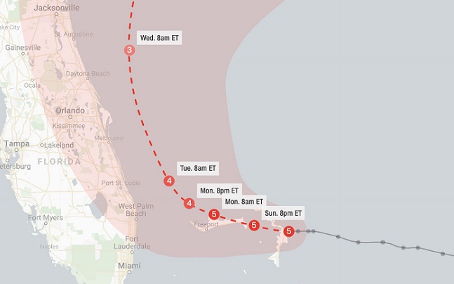
- JUST IN: Hurricane Dorian, a Category 5 storm, made landfall on the Abaco Islands in the Bahamas. The storm is crawling northwestward at a pace of 3 mph, which is walking speed.
- The US: Forecasts show a range of possible landfall sites, from Florida to the Carolinas.
- Where’s Dorian? You can track the storm here.
- In the storm’s path with a weak phone connection? Get the text-only version of top stories.
Hurricane Dorian made landfall moments ago on the Abaco Islands in the Bahamas. The storm is a dangerous Category 5 and is continuing to churn northwestward.
The storm has sustained winds of 185 mph. Gusts over 200 mph are being experienced there while storm surge up to and over 20 feet is likely occurring. Extreme rainfall rates will likely lead to flash flooding.
Here’s what else to expect each day this week:
Monday morning
Tropical storm-force winds will begin to move into the Florida Peninsula on Monday morning, likely occurring first in the West Palm Beach/Port St. Lucie area.
- Outer-Bands from the storm will move through starting Monday morning, but there will also likely be times of sun in between the clouds and showers
- On Monday morning at 8am, the center of Dorian should be just under 100 miles east of West Palm Beach
- The hurricane is expected to still be Category 5 on Monday morning
Monday evening
Dorian is slowly moving northwest and spreading tropical storm-force winds over more of Florida. By 8 p.m. ET Monday, tropical-storm force winds will be pushing into Central Florida.
- The center of Dorian will be around 60 miles from Florida coast between West Palm Beach and Port St Lucie
- Some Hurricane-force wind gusts could be possible beginning Monday evening
- Rain is becoming more frequent and heavier in the outer bands, but there will still be dry periods
Tuesday
By Tuesday, Hurricane Dorian should have weakened to a Category 4, with winds around 140 mph near the center. Tuesday will see Dorian start to make its closest pass to Florida as it turns to the north and parallels the coastline. Again, though the official forecast calls for the center of the storm to stay around 40-50 miles off shore, any slight deviation could bring the eye into Florida. Even if it doesn’t, hurricane force winds are likely to be over land on Tuesday along Florida’s east coast. Rain should be steady but might not be constant, depending on how close the storm gets.
At 8 a.m., the center of Dorian should be within about 50 miles of Port St Lucie/Vero Beach area. It will move northward during the day and evening.
Wednesday
The storm will continue to produce hurricane-force winds as it heads north with some more weakening forecast. There is an increasing risk of strong winds and dangerous storm surge along the coasts of Georgia, South Carolina and North Carolina.
Thursday
This will be the closest approach to the Carolina coast. There is also the possibility of a landfall.
Friday
The storm will near the outer banks of North Carolina.33 min ago
British Royal Navy sends ship to the Bahamas help during Dorian
From CNN’s Duarte Mendonca
The British Royal Navy auxiliary aid ship, RFA Mounts Bay, has been deployed to offer support during Hurricane Dorian, according to the Ministry of Defense press office.
The ship is ready to assist if help is needed in the Bahamas. It is fully equipped, capable of carrying amphibious vehicle and includes a helicopter for rescue and surveying operations, a statement from the department said.
The Royal Navy deploys ships every year ahead of hurricane season across different overseas territories — including the commonwealth areas — as part of their standard protocol to provide humanitarian and disaster relief.
The ship’s current position is not known, but its last whereabouts were near the British Virgin Islands roughly two days ago, the department said.45 min ago
St. Lucie county orders evacuations: “Our concern has grown, and so should yours”
Mandatory evacuations have been ordered for North and South Hutchinson Island, St Lucie County Sheriff Ken Mascara said at an afternoon news briefing.
Manufactured homes and low-laying areas are also under a mandatory evacuation. Effective tomorrow, access to the area will be limited to residents and businesses only, Mascara said.
“This storm is very unpredictable,” said Mascara, who advised residents to get to shelters. “Our concern has grown, and so should yours.”
Authorities warn against anyone who tries to take advantage of homes or businesses that are vulnerable. Last night someone attempted to “burglarize a house that was vacated,” Mascara said.
“We are watching for this kind of activity,” Mascara added.58 min ago
Dorian makes landfall in the Bahamas
Hurricane Dorian made landfall on Elbow Cay in the Bahamas’ Abacos Islands at 12:40 p.m. ET, according to the National Hurricane Center.
The storm is a Category 5 hurricane with 185 mph winds.
“This is a life-threatening situation. Residents there should take immediate shelter. Do not venture into the eye if it passes over your location,” the center said in an advisory.1 hr 13 min ago
You could walk as fast as Dorian is moving
From CNN’s Brandon Miller
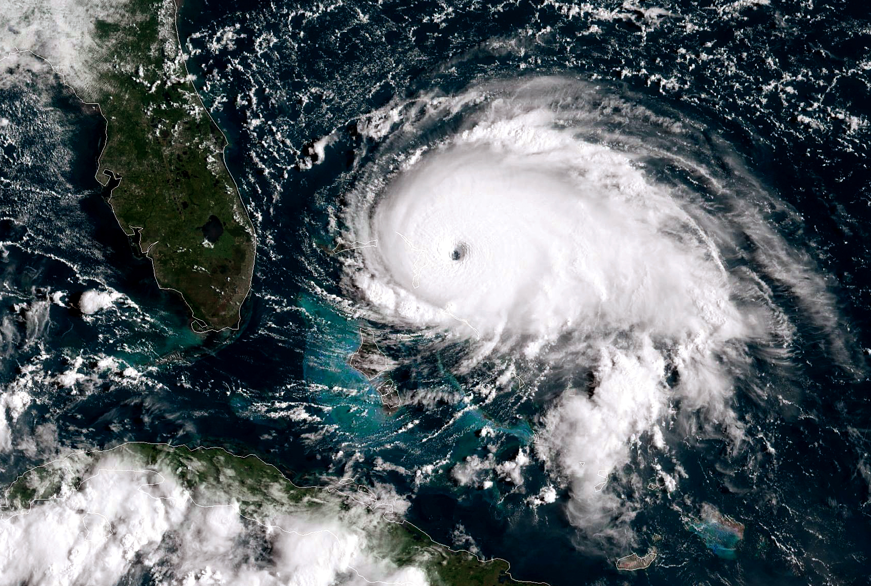
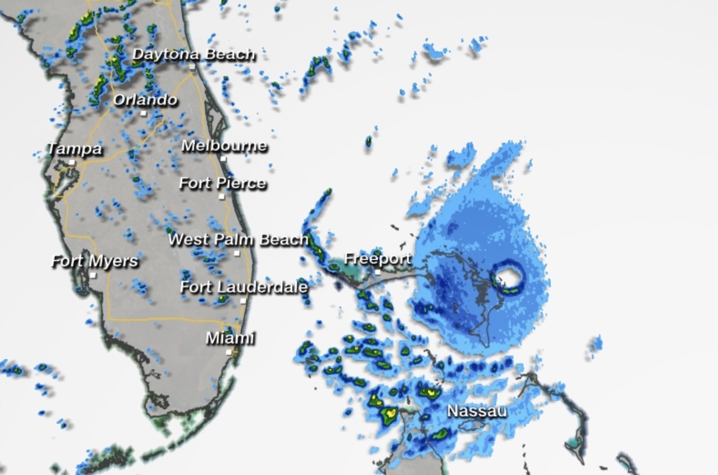
Dorian, which is crawling over the Northern Bahamas, is forecast to travel about 120 miles in the 36 hours between Sunday and Tuesday.
That means the hurricane is averaging about 3 mph — a walking pace.
Dorian has winds of 180 mph, making it the strongest hurricane in modern records for the Northern Bahamas.1 hr 30 min ago
Trump: Dorian is “one of the biggest hurricanes we’ve ever seen”
from CNN’s Nikki Carvajal

President Trump called Hurricane Dorian “one of the biggest hurricanes we’ve ever seen” as he spoke with reporters after returning from Camp David.
The President said he has been tracking the storm and doing “a lot of different things, going over the hurricane.”
“This is now a Category 5,” Trump said. “It seems to be one of the biggest hurricanes we’ve ever seen, and that’s a problem.”
“We have a lot of great people working right now. We don’t know where it’s going to hit but we have an idea,” Trump added.
Trump was accompanied into the White House by Rear Admiral Peter Brown of the US Coast Guard, who warned of “substantial, destructive, life-threatening storm surge” associated with the storm.
“We’ll be learning over the next probably less than 24 hours,” Trump said.
The President will head to FEMA headquarters in Washington Sunday afternoon to receive a briefing on the hurricane. He told reporters that he’ll be holding a press conference after his meetings.
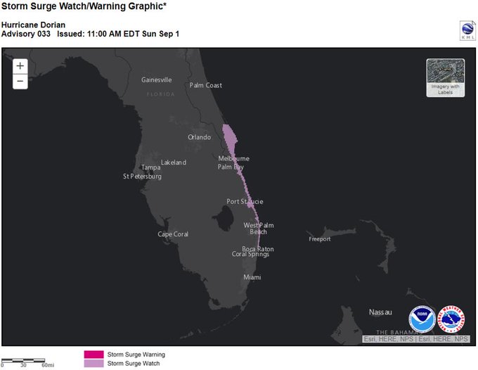
Part of Florida’s coast is under a storm surge watch
Parts of the Atlantic coast of Florida are now under a storm surge watch, according to the National Hurricane Center.
The watch runs from North of Deerfield Beach to the Volusia/Brevard County Line, the center said.
What you need to know: A storm surge watch means there is a possibility of life-threatening inundation from rising water moving inland from the coastline in the indicated locations over the next 48 hours.
Here’s a look at the area on the map:
A Storm Surge Watch has been issued for portions of the east coast of the Florida peninsula from Deerfield Beach north to the Volusia/Brevard County line for the possibility of life-threatening coastal flooding. Promptly follow all evacuation instructions from local authorities.
A county-by-county look at Dorian evacuations in Florida
Parts of Florida are now under mandatory and voluntary evacuation as Hurricane Dorian nears the state. Here’s a breakdown:
MANDATORY EVACUATIONS
Brevard County
Brevard County are now calling for evacuations to begin at 8 a.m. ET Monday. The following residents should start evacuating then:
- Those in mobile homes or manufactured housing
- Those in low-lying, flood-prone areas
- Those with special medical needs such as electrical dependence
- Those who live on the barrier islands, including areas from Kennedy Space Center south to the south beaches, and Merritt Island
The mandatory evacuation was initially to begin at 8 a.m. Sunday. However, the path of the slow-moving Dorian has allowed more time for residents to prepare for a major water and wind event still threatening Brevard County beginning on Tuesday.
Palm Beach County
The eastern half of Palm Beach County is now under a tropical storm warning due to the approach of Hurricane Dorian. Due to this, mandatory evacuations are being ordered for residential structures in Zone A and Zone B in Palm Beach County, effective at 1 p.m. ET today.
- Zone A includes mobile homes, sub-standard housing and low-lying areas prone to water intrusion.
- Zone B generally includes the barrier islands, land areas north and south of the Jupiter Inlet, and other surge-vulnerable areas south along the Intracoastal Waterway to the Broward County line.
Martin County
Martin County officials have announced mandatory evacuations in advance of Hurricane Dorian beginning at 1 p.m. ET. The evacuation applies to:
- Residences on the barrier islands (Hutchinson Island and Jupiter Island)
- Sewall’s Point
- Manufactured/mobile homes
- Homes in low-lying areas
VOLUNTARY EVACUATIONS
Gov. Ron DeSantis’ Office said these counties are under voluntary evacuation orders:
- Osceola County
- Palm Beach County
- Glades County
- Hendry County
- Indian River County
POSSIBLE EVACUATIONS
Volusia County
County Manager George Recktenwald and Emergency Management Director Jim Judge provided updates on Hurricane Dorian’s movement and Volusia County’s preparations during a news conference on Saturday.
Mandatory evacuations may be ordered Monday. This order will be for residents who live on the beachside and in low-lying areas and RV and mobile homes throughout Volusia County. 2 hr 20 min ago
Parts of Florida are now under a hurricane watch
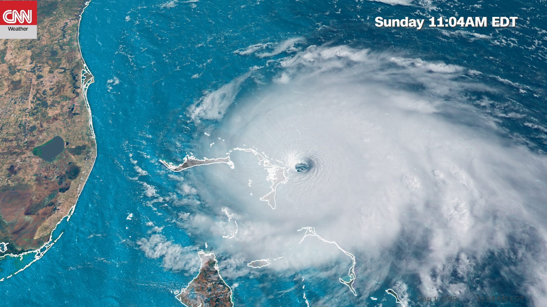
A hurricane watch has been issued for the east coast of Florida from north of Deerfield Beach to the Volusia/Brevard County Line, according to the National Hurricane Center.
Remember: The official track from the center does not call for Dorian to make landfall in Florida, but it will come close enough to bring hurricane-force winds to parts of the state.
Here’s a full list of the watches and warnings in place for the storm:
- A hurricane warning is in effect for Northwestern Bahamas excluding Andros Island
- Hurricane watches are in effect for Andros Island and North of Deerfield Beach to the Volusia/Brevard County Line in Florida
- A storm surge watch is in effect for North of Deerfield Beach to the Volusia/Brevard County Line.
- A tropical storm warning is in effect for North of Deerfield Beach to Sebastian Inlet
- Tropical storm watches are in effect for North of Golden Beach to Deerfield Beach and Lake Okeechobee in Florida.
Watch Hurricane Dorian batter the Bahamas
Local resident David Flint Wood captured this video of the effect Hurricane Dorian is already having on Harbour Island in the Bahamas Sunday morning.
He told CNN’s Patrick Oppmann that he took a wind reading of 45 mph.
Take a look:Play Video2 hr 43 min ago
Florida’s Kennedy Space Center is closed

The Kennedy Space Center in Cape Canaveral, Florida, is currently closed to visitors and will remain closed on Monday.
The center anticipate remaining closed on Tuesday.
“During this closure visitors will not be permitted onto visitor complex grounds,” a statement from the center said. 2 hr 47 min ago
These parts of Martin County are under evacuation orders
Martin County officials have announced mandatory evacuations in advance of Hurricane Dorian beginning at 1 p.m. ET Sunday as the county opens shelters.
Residents are urged to follow the evacuation order, the county said in a news release. Additional evacuation areas may be identified if conditions change.
Residents are also encouraged to consider other options before deciding to go to a shelter.”Due to shifts yesterday it looked better for us, today it looks worse” Michele Jones, Emergency Management Director for Martin County, said.
Water will be shut off at 10 a.m. ET Monday to protect island infrastructure, Jones said.
Dorian is the strongest hurricane in modern records to threaten the Northwestern Bahamas
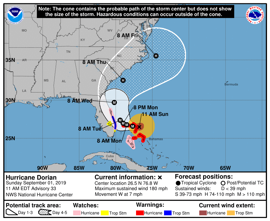
Hurricane Dorian has wind speeds of 180 mph, making it the strongest hurricane in modern records for the Northwestern Bahamas, the National Hurricane Center said in its 11 a.m. ET advisory.
The storm has gusts of up to 220 mph.
“Catastrophic conditions” are occurring in the Abacos Islands, the center said.
Additionally, a hurricane watch has been issued for the east coast of Florida from north of Deerfield Beach to the Volusia/Brevard County Line.
Here’s the latest forecasted path for Dorian:
2 hr 58 min ago
3 stats that show Hurricane Dorian’s power
Hurricane Dorian is a dangerous Category 5 storm. Here’s a look at just how powerful it is:
- With 175 mph maximum winds, Hurricane Dorian is the strongest storm anywhere on the planet this year.
- Dorian is strongest storm to ever track over the Northern Bahamas, and is only the second Category 5 storm to hit anywhere in the Bahamas. Hurricane Andrew in 1992 was the other.
- Dorian strengthening into a Category 5 makes four years in a row that there has been a Category 5 in the Atlantic Basin, a first since reliable satellite measurements began in the 1960s.
3 hr ago
Parts of Indian River County will be under mandatory evacuations on Monday
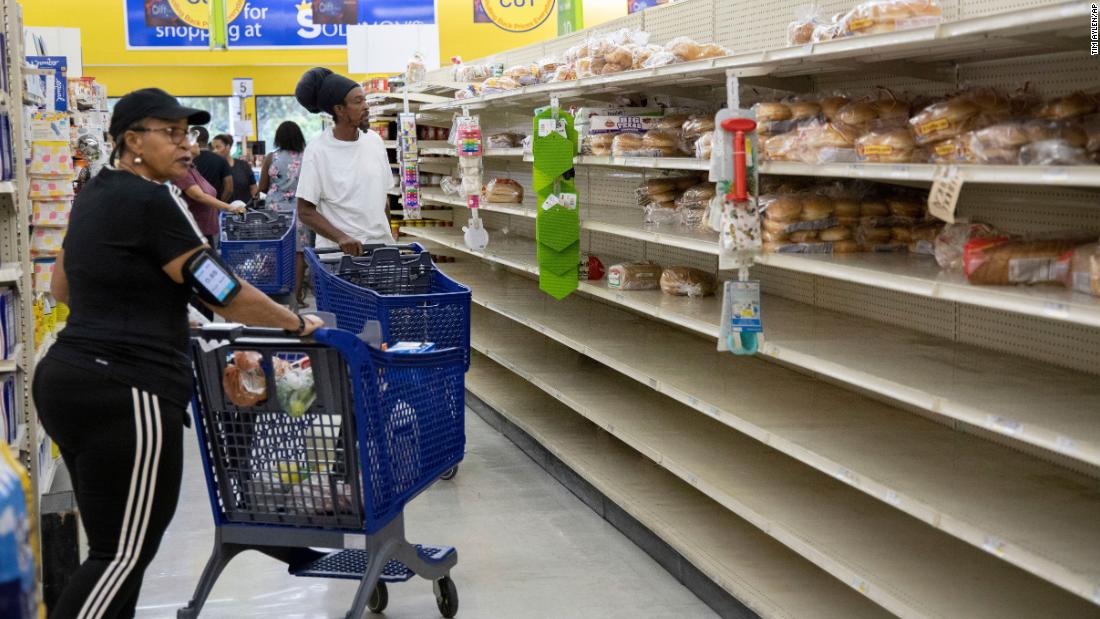
Mandatory evacuations for all residents and visitors east of US Highway 1 in Indian River County will be issued Monday, Indian River County Sheriff’s Office said in a news release.
Residents are urged to continue preparations, as Dorian has moved west. The center of the storm is still forecast to stay offshore, but will make a close approach to east central Florida Monday through Wednesday, the sheriff’s office added.
Tropical-storm-force winds are likely along the coast. Public shelters are prepared to open tomorrow, including the special needs and pet friendly locations. Shelter locations and times of opening will be announced tomorrow morning.3 hr 8 min ago
Florida senator to residents: “You have to take care of yourself first”
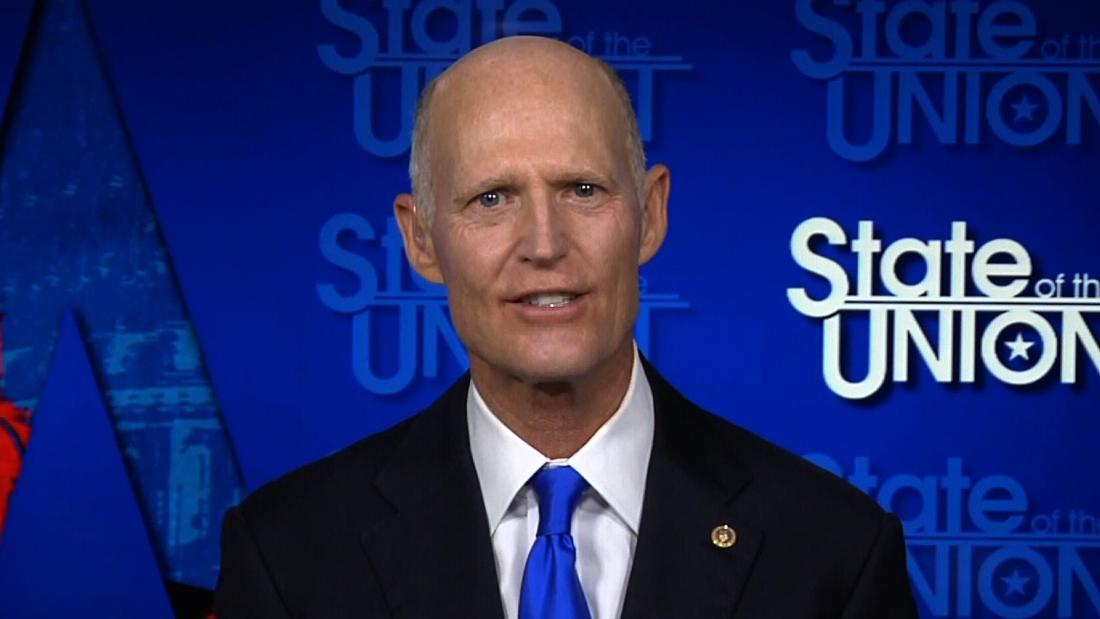
Florida Sen. Rick Scott urged his state’s residents to heed evacuation orders as Hurricane Dorian approaches.
“There’s good emergency management at the state, at the local level,” he said on CNN. “But you have to take care of yourself first. And so if you decide not to evacuate when they tell you to, or if you wait, that’s really the risk.”
Scott added that he’s been in contact with the White House.
“I was at FEMA yesterday, I’ll be going back there today with President Trump. They’ve told me they’ll have the resources. At my disasters in Florida, they’ve always shown up and done their job. FEMA has done a good job,” he said.3 hr 33 min ago
Evacuation orders issued in Palm Beach County
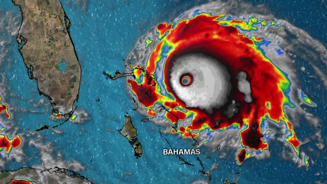
Mandatory evacuations have been ordered for Palm Beach County as tropical-storm-force winds from Hurricane Dorian are expected to hit the area within 36 hours. Residential structures in Zone A and B must be evacuated effective at 1 p.m. ET, Palm Beach County said in a news release.
Zone A includes mobile homes, sub-standard housing and low-lying areas prone to water intrusion. Zone B generally includes the barrier islands, land areas north and south of the Jupiter Inlet, and other surge-vulnerable areas south along the Intracoastal Waterway to the Broward County line, the county said.
Most of Palm Beach County is not being evacuated and residents should shelter within the county if possible. With the unpredictable nature of Hurricane Dorian, evacuating north is not recommended.
At 1 p.m. ET today, Palm Beach County will open seven general-population shelters, as well as the special needs shelter at the South Florida Fairgrounds and the pet-friendly shelter at West Boynton Recreation Center.
The seven general population shelters are:
- Dr. Mary McLeod Bethune Elem. School, 1501 Avenue U, Riviera Beach
- Independence Middle School, 4001 Greenway Dr., Jupiter
- Lakeshore Middle School, 425 W Canal St N, Belle Glade
- Pahokee Middle School, 850 Larrimore Rd, Pahokee
- Palm Beach Gardens High School, 4245 Holly Dr., Palm Beach Gardens
- Palm Beach Central High School, 8499 Forest Hill Blvd, Wellington
- Park Vista High School, 7900 Jog Rd, Lake Worth
The special needs shelter is located at 9067 Southern Boulevard, West Palm Beach. If you are registered, you should have received notification. The pet-friendly shelter is located at 6000 Northtree Boulevard, Lake Worth.
For more information on the shelters, and other information about the hurricane, residents cant visit www.pbcgov.com/dem. 4 hr 4 min ago
Hurricane Dorian is the strongest storm on the planet this year
By CNN’s Brandon Miller
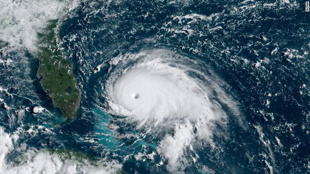
Dorian continues to intensify and the maximum winds are now up to 175 mph, according to data from Hurricane Hunter aircraft flying through the storm.
This makes Hurricane Dorian the strongest storm anywhere on the planet this year.
“The eyewall of catastrophic Hurricane Dorian is currently reaching the Abaco islands,” the NHC said in a special update at 9:30am. “This is a life-threatening situation.”
RELATED ARTICLES
Recent Posts
- Big arrangements are made by a nervous Harris campaign to secure a close victory.
- Assault on peace: Hammas deadliest attack on israle on Oct 07 , instigated Midle East Crisis:
- Israel marked “solemn” anniversary commemorating 7/10 deadly attacks:
- Trump impeachment: Trump lashed out over his impending impeachment in an irate letter to Nancy Pelosi, accusing her of declaring “open war on American democracy”.
- hotness breaks its records in Australia :


